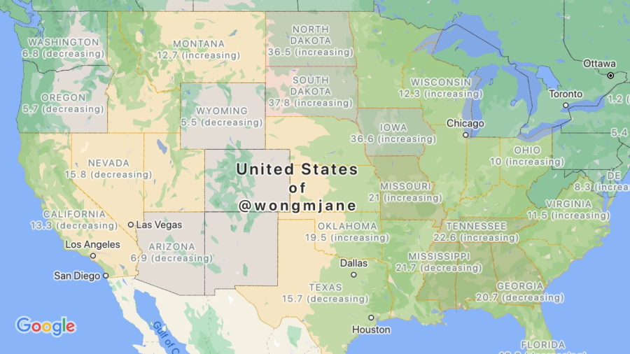
As seen in the screenshot below, Google may simply name the map layer “COVID-19” and include the number of new cases below the description and data sources list. Additionally, there are also a few map options to choose from, including Transit, Traffic, Bicycling, and several others.
(idk if it’s new) pic.twitter.com/qqPUfmn5pN — Jane Manchun Wong (@wongmjane) September 4, 2020 To that end, Google is said to be obtaining all of its information from various sources, including the New York Times, Wikipedia, Johns Hopkins University and Brihanmumbai Municipal Corporation. Naturally, this is a step taken by Google to ensure that an accurate number of statistics are always provided to Map users. The map layer also highlights the severity of outbreaks based on numbers displayed between states and highlighted areas within a region. This is done for users to better identify if an outbreak is currently on the rise or facing a decrease.
At the time of writing, there is still no word from Google as to when it plans to roll out the feature, or if it will be available to other countries outside the US, let alone Malaysia. For now, we will just have to be patient until Google implements this update on a global scale. (Source: 9to5Google, Twitter [1])